Oh It Rained… The Triad Barely Stays Afloat
July is now half over, but the National Climatic Data Center just released their June ‘State of the Climate Report’ and it contained some interesting trends.
First and foremost, after coming off of an incredibly wet pattern that just ended today (Monday, July 15th) June was when it all began. For us in the Triad our 21 of 22 day stretch of rain started back on June 23rd. In total the Triad accumulated 6.86″ of rain. Ironically, there wasn’t one daily rainfall record broken. The greatest rainfall amount came on July 10th, however, when 1.40″ fell with most of it coming within just a couple of hours. As for the entire month of June the Triad received a total of 8.37″ of rain, which was 4.64″ above normal. The last time the Triad had a surplus in June was in 2009 when 5.67″ fell.

GSO Rainfall Departure From Normal In June
To date, the Triad has had it’s second wettest summer on record dating back to 1944 with 11.93″ of rain. The wettest summer, to date, was in 1965 when 12.42″ of rain had fallen.

GSO Experiencing 2nd Wettest Summer On Record
For the entire year the Triad has received 30.96″ of rain which is 8.48″ above normal. Except for the first half of January, the Triad has had a surplus of rainfall all year that all started with an impressive 2.45″ of precipitation that fell on January 17th (3″ of snow).

2013 Temperature and Precipitation Trends in GSO
North Carolina as a whole also had a very wet June that obviously continued into the first half July. In fact, North Carolina had its second wettest June on record dating back to 1894. The first half of the year (Jan-June) was also pretty wet where it was the 9th wettest on record.

June 2013 Precipitation State Rankings
As a nation, it was the 13th wettest June on record.

US Has 13th Wettest June
As we look ahead to the rest of July and into the late summer and early fall months there are no indications that we will enter another wet pattern similar to what we just came out of. The Climate Prediction Center has given North Carolina equal chances of below or above normal amounts of precipitation. And while drought is the last thing that we need, a little bit of dry weather wouldn’t be such a bad thing around here. Case in point, in the last 30 days the Triad has received more than 200% of it’s normal rainfall!

Precipitation Outlook For August, September & October
While the long term prediction is for an equal chance of above or below normal amounts of precip, we will still have to watch out for the tropics. A single tropical storm could reek havoc on North Carolina, not necessarily with winds, but with the potential for days of torrential rains. So far (knock on wood) the hurricane season has been relatively quiet with only three named storms. Don’t let the low number fool you, however, the peak of hurricane season is not until September 10th. We still have a long way to go!
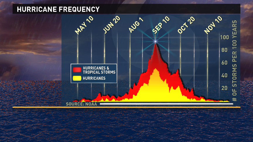
Hurricane Frequency In The Atlantic Basin
As for right now, enjoy the return to somewhat of a normal weather pattern in the Triad with that fairly persistent 30% chance of afternoon scattered showers and thunderstorms.
Until next time…
Grant
Posted on July 15, 2013, in Weather. Bookmark the permalink. Leave a comment.

Leave a comment
Comments 0